


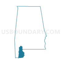
Rabun Fire House, Baldwin County, Alabama
About
Outline

Summary
| Unique Area Identifier | 521166 |
| Name | Rabun Fire House |
| County | Baldwin County |
| State | Alabama |
| Area (square miles) | 51.14 |
| Land Area (square miles) | 51.06 |
| Water Area (square miles) | 0.08 |
| % of Land Area | 99.84 |
| % of Water Area | 0.16 |
| Latitude of the Internal Point | 31.00270050 |
| Longtitude of the Internal Point | -87.72353110 |
Maps

Graphs
Select a template below for downloading or customizing gragh for Rabun Fire House, Baldwin County, Alabama


Neighbors
Neighoring Voting District (by Name) Neighboring Voting District on the Map
- Bay Minette City Hall & Civic Center, Baldwin County, AL
- Lottie Fire Department, Baldwin County, AL
- Perdido Elementary School, Baldwin County, AL
- Stockton Fire House, Baldwin County, AL